
SituationLiving fileEU 24-hour delay of Gaza and West Bank satellite imagerygeopolitics
EU has quietly delayed Gaza and West Bank satellite imagery by 24 hours since March, Bellingcat found
As of 30 Oct · daily
Hottest Pulse: Israel–Palestine · Gaza Combat and Humanitarian Catastrophe, 89 of 100 (critical)
Every line: 1 Oct to 30 Oct, on one 0 to 100 scale.
Every day on file
Last report yesterday1 day from the Daily, newest first. The latest is open here with their pictures and numbers; earlier days open in their Daily.
Fri, 30 Oct 2026 · day's report → steady, flat pace
EU has quietly delayed Gaza and West Bank satellite imagery by 24 hours since March, Bellingcat found
The Israeli-Palestinian conflict centers on Gaza, where war has caused severe humanitarian hardship, and the occupied West Bank, where Palestinians face settler violence, demolitions and movement restrictions under Israeli control. A fragile ceasefire and international plans for transitional governance and stabilization have not ended daily risks for civilians. Open satellite imagery has become a key way outsiders verify what is happening on the ground when access is limited.
Base map: Natural Earth (public domain). Locations: Ohmega, from today's developments; approximate. Disputed areas: Natural Earth (public domain). Shipping data: IMF PortWatch. Interactive basemap: OpenFreeMap, © OpenMapTiles, data © OpenStreetMap contributors.
Grid impact · Ohmega analysis last report 15 days ago
Last 30 days, of 70 GW installed (nameplate) capacity the ledger knows. A plant can appear under more than one figure (claimed, then reported, then confirmed), so the figures overlap and are not added; the bars count each plant once, at the firmest thing said about it.
- Confirmed damaged or destroyed
- Damage reported
- Claimed struck
- Restored
3 plants named
- 10-13Kiev · 440 MW hydro · Damage reported · said by Daily intelligence report
- 10-14Kyiv-4 (Darnytska) Power Plant · 160 MW thermal & chp · Damage reported · said by reported via france24.com
- 10-14Kyiv CHP-4 · capacity unknown other · Damage reported · said by Daily intelligence report (d5), reported via kyivindependent.com
Ohmega analysis from the asset ledger and WRI/OpenStreetMap capacity. Capacity is nameplate, not output; a status is not an outage duration; plant coverage is incomplete.
- 29 Oct
- 2
- 13 Jul3
Assessment and what changed · the full read, since yesterday
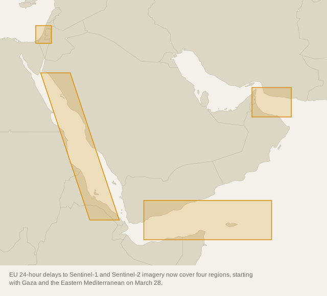
Bellingcat found on Oct 29 that the EU has delayed free Copernicus Sentinel-1 and Sentinel-2 imagery over Gaza, parts of the West Bank and the Eastern Mediterranean by 24 hours since March 28, 2026, reducing real-time independent verification. The EU said the unanimous, open-ended measure is for security amid the wider Middle East war, not Gaza events specifically, and declined to detail boundaries or other delayed areas. The finding matters because the delay coincided with active demolitions and displacement in Hebron this week.
More developments (1)
- 11 Mar4
Strike & status log (18) · named places, who says what, this week
Named places and things the reports say something dated about. Each line gives who says it: “claimed struck” is a party's own word, and only a second source turns it into reported or confirmed damage.
- 28 OctAzot Novomoskovsk (site) · Damage reported · said by Daily intelligence report kyivindependent.com ↗
- 28 OctNovolipetsk Steel (NLMK Lipetsk) (site) · Damage reported · said by Daily intelligence report kyivindependent.com ↗
- 27 OctPivdenny Bridge (bridge) · Damage reported · said by Daily intelligence report atlanticcouncil.org ↗
- 27 OctPivdenny Bridge (bridge) · Damage reported · said by reported via kyivindependent.com kyivindependent.com ↗ meduza.io ↗
- 27 OctState University of Trade and Economics (site) · Damage reported · said by reported via kyivindependent.com kyivindependent.com ↗ meduza.io ↗
- 26 OctKing Khalid International Airport (airbase) · Restored · said by reported via dawn.com dawn.com ↗ thehindu.com ↗
- 25 OctKing Khalid International Airport (port) · Claimed struck · said by Houthi spokesman Yahya Saree dawn.com ↗ thehindu.com ↗
- 25 OctKing Khalid International Airport (port) · Restored · said by Daily intelligence report dawn.com ↗ thehindu.com ↗
- 25 OctMegaGRINN shopping complex (site) · Damage reported · said by Belgorod Operational Headquarters kyivindependent.com ↗ dw.com ↗
- 24 OctAramco Yanbu Refinery (refinery) · Claimed struck · said by Houthi spokesman Yahya Saree dawn.com ↗ thehindu.com ↗
- 24 OctKing Khalid Air Base (airbase) · Claimed struck · said by Houthi spokesman Yahya Saree dawn.com ↗ thehindu.com ↗
- 24 OctKing Khalid International Airport (airbase) · Claimed struck · said by Houthi spokesman Yahya Saree dawn.com ↗ thehindu.com ↗
- 24 OctOmsky Kauchuk petrochemical plant (refinery) · Claimed struck · said by Daily intelligence report kyivindependent.com ↗ tass.com ↗
- 24 OctOzon logistics hub (fuel depot) · Damage confirmed · said by governor Vitaliy Khotsenko kyivindependent.com ↗ tass.com ↗
- 24 OctOzon logistics hub (fuel depot) · Claimed struck · said by Daily intelligence report kyivindependent.com ↗ tass.com ↗
- 24 OctRabigh Refinery (refinery) · Claimed struck · said by Houthi spokesman Yahya Saree dawn.com ↗ thehindu.com ↗
- 24 OctTolyattikauchuk (refinery) · Claimed struck · said by General Staff kyivindependent.com ↗ tass.com ↗
- 24 OctYeysk airfield (airbase) · Claimed struck · said by General Staff kyivindependent.com ↗ tass.com ↗
Numbers and actors · statistics, flows and rates
Who they are · size
Balance sheet · debt, budget, current account, reserves
Annual statistics: latest year on record for each figure (IMF figures for this year are estimates), bars on one scale per column, line = the last ten years. Tap an actor for every year, rank, energy, ranked trade and sources. All actors →
Outlook, watch list and background
- Whether the EU publishes the precise boundary, legal basis and review date for the Eastern Mediterranean/Gaza delay
- Whether Sentinel-1 and Sentinel-2 timeliness over Gaza returns to ~4 hours or stays at ~24 hours in coming passes
- Any legal or parliamentary challenge in the EU over the unpublished Council Decision 2026/1716 and its corrigendum
- Changes to Planet Labs managed distribution that would restore or further restrict commercial high-resolution coverage
- 8 Oct 2025A tenuous ceasefire has been in place since Oct 8, 2025 as first phase of the US-brokered Comprehensive Plan to End the Gaza Conflict, endorsed by UN Security Council Resolution 2803 on Nov 17, 2025, which welcomed a Board of Peace chaired by the US President and authorized an International Stabilization Force. Explains why real-time satellite monitoring of Gaza and the West Bank remains central to assessing ceasefire compliance and civilian harm. press.un.org ↗
- 15 Oct 2026UN Security Council quarterly debate Oct 15, 2026 heard alarm over perilous life in Gaza and unprecedented settler violence and expansion in the West Bank; Acting Special Coordinator Ramiz Alakbarov said after visiting Gaza Oct 11-12 the ceasefire 'exists in name only' along the Yellow Line, citing about 1,500 fatalities since the ceasefire. Shows the humanitarian and protection context in which a 24-hour imagery lag limits independent documentation. press.un.org ↗
- 23 Oct 2026On Oct 23, 2026 two Palestinian gunmen killed two Israeli soldiers at a checkpoint in Hebron, prompting Israel to announce a full West Bank lockdown and operations at over 400 locations; UN reported about 3,000 Palestinians remain displaced from two Hebron neighbourhoods in the 72 hours before Oct 30. Immediate case where delayed western Hebron imagery on Oct 26 inhibited real-time verification of demolitions and displacement. bellingcat.com ↗
Base map: Natural Earth (public domain). Locations: Ohmega, from today's developments; approximate. Disputed areas: Natural Earth (public domain). Shipping data: IMF PortWatch. Interactive basemap: OpenFreeMap, © OpenMapTiles, data © OpenStreetMap contributors.
researched reported · Most reported: Brussels, Gaza, Gulf of Oman
Background in 60 seconds
written 30 OctOpen satellite imagery is a shared window on war and shipping lanes. The European Union runs Copernicus, whose Sentinel-1 and Sentinel-2 satellites normally publish earth-observation data openly and quickly, while U.S. company Planet Labs sells high-resolution commercial images. Both have withheld timely views of the Middle East when governments argued real-time pictures could be tactically leveraged to target allied personnel and civilians or to threaten the EU, its members or allies. A delay does not erase the picture but removes its immediate military value, while also limiting independent checks on destruction, aid and movement through places like Gaza, the West Bank and the Sea of Oman.
Who is doing what to whom
8 actors in play; no relations recorded yet.
- Copernicus programme 1 mention
- EU Council 1 mention
- EU Member States 1 mention
- EU spokesperson 1 mention
- European Commission 1 mention
Belgium, Palestine and United States, by the numbers
 Belgium
 Palestine
 United States
Every bar in a row is on that row's one scale. Latest year available for each figure; sources on each actor's page.
5 states involved
Open one to see everything else it is part of.

Attacks reported
attack log →≥ 5,570 events in or near its main states, last 30 days reported by the sources; the strongest are listed. No source sees every attack.
- 2026-10-30 · Armed clash · Rassvet, Kaliningradskaya Oblast', Russia · GDELT ↗ · machine-coded
- 2026-10-30 · Armed clash · Los Angeles, California, United States · GDELT ↗ · machine-coded
- 2026-10-30 · Air or drone strike · Petersburg, Sankt-Peterburg, Russia · GDELT ↗ · machine-coded
- 2026-10-30 · Assault or killing · Washington, District of Columbia, United States · GDELT ↗ · machine-coded
GPS interference
all zones →≥ 1 zones over its main states on 2026-10-30: aircraft there reported poor navigation accuracy, a sign of jamming or spoofing, not proof of who is responsible.
- Low · 5% of 79 aircraft observations degraded · 50.5, 3.5
On the record (1)
1 statement, newest first
 Vladimir Putin · President, Russia · 20 Oct
paraphrase Western sanctions against Russia are breaking records in their number and ineffectiveness, as well as in the amount of damage they cause to those imposing them.
A statement shows what was said, not that it is true. The whole record →
The numbers
3 figures tracked.
Where it's heading
Linked situations
- Gaza war and West Bank settler violence diplomatic fallout EU 24-hour delay of Gaza and West Bank satellite imagery → Gaza war and West Bank settler violence diplomatic fallout… 30 Oct
Daily reports that covered it
Rebuilt 2026-10-30, and again as new reports land.